Table of Contents
ToggleRESOURCES – INTRO
Look around you—everything you use in daily life, from water and air to books, roads, and even your skills, is a resource. But have you ever wondered why some regions develop faster than others? The answer lies in how effectively resources are used. Understanding resources is the first step towards understanding development, sustainability, and our role in conserving nature.
*What are Resources?
Anything available in our environment that can be used to satisfy our needs is called a resource — provided it is technologically accessible, economically flexible , culturally acceptable.
In simple words, not everything in nature is a resource. It becomes a resource only when:
- We have the technology to use it
- It is affordable to use
- It is useful for society
*Importance of Resources
Resources are the foundation of development. Without them, no country can progress. Their importance can be understood in the following way:
- Basis of Survival: Resources like air, water, food, and land are essential for life. Without them, survival is impossible.
- Support Economic Development: Industries, agriculture, transport — all depend on resources. Example: Fertile soil helps in farming, minerals help in industries.
- Improve Quality of Life: Resources help in providing better housing, healthcare, education, and technology, making life comfortable.
- Drive Technological Advancement: Availability of resources like minerals and energy fuels technological growth. Example: Petroleum supports transport and modern industries.
- Regional Development: The availability of resources influences how developed a region is. Areas rich in resources often develop faster compared to resource-poor regions.
*Human Beings as a Resource
When people have education, skills, and good health, they can work efficiently and contribute to development. In this way, they become a valuable resource for the country. This concept is also known as Human Resource Development (HRD).

The diagram shows that human beings are at the center of resource development, connecting nature, technology, and institutions. Nature provides raw materials like land and water, but they become useful resources only when humans use their knowledge and skills. Humans develop technology to transform these natural elements into usable forms and create institutions (like laws and organizations) to manage and distribute them properly. Thus, human beings act as the link that controls and coordinates everything, making them the most important resource.
CLASSIFICATION OF RESOURCES
Resources are classified into four main categories based on:
- Origin
- Exhaustibility
- Ownership
- Status of Development
Each type helps us understand resources from a different perspective
1.Based on Origin
This classification tells us where resources come from.
- Biotic Resources: These are obtained from living organisms. Example: Plants, animals, forests, fisheries
- Abiotic Resources: These come from non-living things. Example: Rocks, minerals, metals, water
# This classification is important because it helps us understand the nature and source of resources.
2.Based on Exhaustibility
This classification focuses on whether resources can be used again or not.
- Renewable Resources: These can be replenished or renewed naturally over time. Example: Solar energy, wind energy, water
- Non-Renewable Resources: These are limited and take millions of years to form. Once used, they cannot be easily replaced. Example: Coal, petroleum, natural gas
# This classification is directly linked with sustainable development, as it teaches us to use limited resources carefully.
3.Based on Ownership
This classification shows who owns the resources.
- Individual Resources: Owned by private individuals. Example: Land, house, wells
- Community-Owned Resources: Used by a group/community. Example: Public parks, playgrounds, grazing grounds
- National Resources: Owned by the country (government). Example: Roads, railways, rivers, forests
- International Resources: Beyond national boundaries and regulated by international institutions. Example: Oceanic resources beyond 200 nautical miles
# This classification helps in proper management and fair distribution of resources.
4.Based on Status of Development
This classification explains how developed or usable a resource is.
- Potential Resources: Available but not fully used yet. Example: Wind and solar energy in Rajasthan and Gujarat
- Developed Resources: Surveyed and currently in use. Example: Developed agricultural land
- Stock: Resources available but cannot be used due to lack of technology. Example: Hydrogen as a fuel (not fully usable yet)
- Reserves: Part of stock that can be used with existing technology but is conserved for future. Example: Water in dams, forests
# This classification highlights the role of technology and planning in resource use.
DEVELOPMENT OF RESOURCES
Development of resources means using resources in a planned, systematic, and sustainable way so that they are available for both present and future generations.
*Problems Caused by Indiscriminate Use of Resources
The irrational and excessive use of resources has led to multiple issues:
1. Depletion of Resources: Many important resources like coal, petroleum, and forests are being used rapidly, leading to their exhaustion.
2. Concentration of Resources: Resources are concentrated in the hands of a few people or countries, creating a rich–poor divide.
3. Global Inequalities: This unequal distribution has caused economic and social inequalities across the world.
4. Environmental Degradation
*Need for Sustainable Development
-To overcome these problems, it is important to follow sustainable development.
-It means using resources in a way that meets present needs without compromising the ability of future generations to meet their own needs.
# History of Sustainable Development
The Rio Earth Summit (1992) was a major international meeting held in Rio de Janeiro where countries realised that development should go hand-in-hand with environmental protection. During this summit, an important action plan called Agenda 21 was introduced, which guided nations on how to use resources carefully and promote sustainable practices in daily life.
Building on this idea, the Sustainable Development Goals (2015) were introduced by the United Nations to take this vision further. These include 17 global goals to be achieved by 2030, focusing on overall development of society.
RESOURCE PLANNING
Resource planning is the careful strategy for using resources wisely, efficiently, and sustainably to meet present and future needs.
It becomes necessary because:
- Resources are limited
- They are unevenly distributed across regions
- Overuse can lead to environmental problems
*Steps Involved in Resource Planning
Resource planning is a systematic process that includes the following steps:
1. Identification and Inventory of Resources
This involves:
- Surveying and mapping resources
- Identifying their type, quality, and quantity
Example: Mapping mineral-rich areas or water resources
2. Developing a Planning Structure
This step focuses on:
- Using appropriate technology, skills, and institutions
- Creating policies and strategies for resource use
It ensures that resources are used in the best possible way.
3. Matching Resource Development Plans with Overall Development
- Resource use should align with national development goals
- Balanced use ensures both economic growth and conservation
This step connects resource planning with sustainable development.
*Importance of Resource Planning
Resource planning plays a key role in development:
- It ensures efficient and careful use of resources
- It helps in reducing regional disparities
- It prevents over-exploitation and environmental damage
- It promotes sustainable development
LAND RESOURCES
Land is a resource of utmost importance. It supports natural vegetation, wildlife, human life, economic activities, transport, and communication systems. However, land is an asset of a finite magnitude; therefore, it is careful and planned use is essential.
*India’s Relief Features
India possesses a variety of relief features. The distribution of land is roughly divided as follows:
- Plains (43%): Provide facilities for agriculture and industry.
- Mountains (30%): Ensure the perennial flow of some rivers and provide facilities for tourism and ecological aspects.
- Plateaus (27%): Possess rich reserves of minerals, fossil fuels, and forests.
*Land Utilization
In India, land resources are used for the following purposes:
1. Forests:
- Areas specifically designated for forest cover.
2. Land not available for cultivation:
- Barren and waste land.
- Land put to non-agricultural uses (e.g., buildings, roads, factories)
3. Other uncultivated land (excluding fallow land):
- Permanent pastures and grazing land.
- Land under miscellaneous tree crops and groves (not included in net sown area).
- Culturable waste land (left uncultivated for more than 5 agricultural years).
4. Fallow lands:
- Current fallow: Left without cultivation for one or less than one agricultural year.
- Other than current fallow: Left uncultivated for the past 1 to 5 agricultural years.
5. Net Sown Area:
- Area sown at least once in a year.
- Area sown more than once in an agricultural year plus net sown area is known as Gross Cropped Area.
*Land Use Pattern in India
The use of land is determined by both physical factors (topography, climate, soil types) and human factors (population density, technological capability, culture, and traditions).
1. Physical Factors (Natural Factors)
- Relief (Topography)
Plains are suitable for farming, transport, and settlements due to flat land.
Hilly and mountainous areas are less suitable for agriculture and are mainly used for forests or grazing.
- Climate
Areas with good rainfall and moderate temperature support agriculture.
Extreme climates (very dry or very cold) limit land use.
- Soil
Fertile soil is ideal for farming, while poor or rocky soil is used for other purposes like construction or grazing.
2. Human Factors
- Population Density
High population increases demand for land for housing and industries, reducing agricultural land.
- Technology
Better technology improves land use by increasing productivity and making difficult areas usable.
- Culture and Traditions
People’s lifestyle and practices influence how land is used, such as farming or grazing.
# Physical factors decide the natural suitability, while human factors decide the actual use of land.
*Land Degradation
Land degradation refers to the decline in the quality and productivity of land. It is a serious problem because it reduces the ability of land to support life and economic activities.
Causes of Land Degradation
Different regions in India face land degradation due to different human activities:
- Deforestation & Mining: Cutting of trees leads to soil erosion and loss of fertility. In states like Jharkhand, Chhattisgarh, Madhya Pradesh, and Odisha, deforestation due to mining has caused severe land degradation. Mining sites are abandoned after excavation, leaving deep scars.
- Overgrazing: Excessive grazing by animals damages vegetation cover. In states like Gujarat, Rajasthan, Madhya Pradesh, and Maharashtra, overgrazing is a main reason for land degradation.
- Over-irrigation: In Punjab, Haryana, and western Uttar Pradesh, over-irrigation leads to waterlogging, which increases salinity and alkalinity in the soil.
- Industrial Dust: The grinding of limestone for the cement industry and calcite and soapstone for the ceramic industry generates huge quantities of dust, which settles on land and retards the infiltration of water into the soil.
*Methods of Land Conservation
To solve the problems of land degradation, we can adopt the following steps:
- Afforestation and proper management of grazing.
- Planting of shelterbelts of plants.
- Control on overgrazing.
- Stabilization of sand dunes by growing thorny bushes (especially in arid areas).
- Proper management of waste lands and control of mining activities.
- Proper discharge and disposal of industrial effluents and wastes after treatment.
SOIL AS A RESOURCE
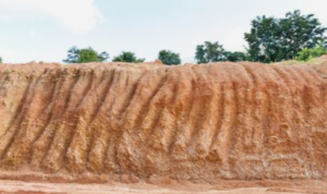
Soil is the uppermost layer of the Earth’s crust. Soil is arguably the most important renewable natural resource. It is the medium of plant growth and supports different types of living organisms on the earth. Think of it as a living system—it takes millions of years to form soil up to a few cm in depth. It is formed due to the weathering of rocks over a long period of time.
*Factors Influencing Soil Formation
- Parent Rock/Bed Rock: Determines the color, texture, and mineral content.
- Climate: Influences the rate of weathering and the type of vegetation.
- Relief: Altitude and slope determine the accumulation of soil.
- Vegetation & Other Life Forms: Add organic matter (humus) to the soil.
- Time: Determines the thickness of the soil profile.
Additionally, natural forces like change in temperature, actions of running water, wind, and glaciers contribute significantly to soil formation. Soil consists of both organic (humus) and inorganic materials.
*Classification of Soils in India
India has varied relief features, landforms, climatic realms, and vegetation types. These have contributed to the development of various types of soils.
1. Alluvial Soil

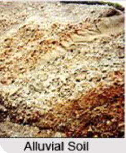
This is the most widely spread and important soil in India, covering the entire Northern Plains.
–Formation: Deposited by three important Himalayan river systems—the Indus, the Ganga, and the Brahmaputra.
- Bangar: Old alluvial soil, higher concentration of kanker nodules.
- Khadar: New alluvial soil, more fine particles and more fertile than Bangar.
2. Black Soil

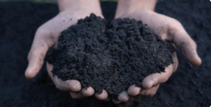
Also known as Regur soil or Black Cotton Soil, as it is ideal for growing cotton.
-Formation: Formed from the weathering of basalt (lava flows) over the Deccan Trap region.
-Texture: Extremely fine or clayey. It is famous for its capacity to hold moisture for long periods.
-Chemical Composition: Rich in soil nutrients such as Calcium Carbonate, Magnesium, Potash, and Lime. It is typically poor in Phosphoric contents.
-Presence: Covers plateaus of Maharashtra, Saurashtra, Malwa, Madhya Pradesh, and Chhattisgarh.
-Unique Property: Develops deep cracks during hot weather, which helps in proper aeration of the soil.
3. Red and Yellow Soils

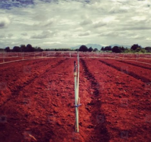
-Formation: Red soil develops on crystalline igneous rocks in areas of low rainfall in the eastern and southern parts of the Deccan plateau.
-Texture: Generally loamy in the surface layer and more clayey in the sub-soil.
-Colour: It looks red due to the diffusion of iron in crystalline and metamorphic rocks. It looks yellow when it occurs in a hydrated form.
-Presence: Odisha, Chhattisgarh, southern parts of the middle Ganga plain.
4. Laterite Soil

The word laterite comes from the Latin word ‘later’ meaning brick.
-Formation: Develops under tropical and subtropical climates with alternate wet and dry seasons. It is the result of intense leaching due to heavy rain.
-Texture: Generally coarse in texture and Deep to Very Deep in profile.
-Chemical Composition: Result of intense leaching. It is rich in Iron Oxide and Aluminium but deficient in Nitrogen, Phosphate, and Calcium. Humus content is low because microorganisms (decomposers) are destroyed by high temperatures.
-Features: Mostly deep to very deep, acidic ($pH < 6.0$), and generally deficient in plant nutrients.
-Uses: After adopting appropriate soil conservation techniques, it is useful for growing tea and coffee (Karnataka, Kerala) and cashew nuts (Tamil Nadu, Andhra Pradesh).
5. Arid Soils
-Features: Range from red to brown in color.
-Texture: Range from sandy in texture and saline in nature. In some areas, the salt content is so high that common salt is obtained by evaporating the water.
-Composition: Due to the dry climate and high temperature, evaporation is faster, and the soil lacks humus and moisture.
-Kanker Layer: The lower horizons are occupied by kanker because of increasing calcium content downwards, which restricts the infiltration of water.
6. Forest Soils
-Location: Found in the hilly and mountainous areas where sufficient rain forests are available.
-Texture: Loamy and silty in valley sides and coarse-grained in the upper slopes.
-Nature: In the snow-covered areas of Himalayas, these soils experience denudation and are acidic with low humus content.
Soil Erosion
Soil erosion is the denudation of the soil cover and its subsequent washing down.
In simple terms, Soil erosion is the removal of the top fertile layer of soil by agents like wind and water.
This topsoil is rich in nutrients and is most suitable for plant growth. Once it is removed, the land becomes less productive and may even turn barren over time.
*Causes of Soil Erosion
1. Deforestation
Cutting down trees removes the natural cover that holds soil together. Without roots to bind it, the soil becomes loose and is easily washed away by rain or blown away by wind.
2. Overgrazing
When too many animals graze on the same land, they remove the grass cover. This exposes the soil and makes it more vulnerable to erosion by wind and water.
3. Construction and Mining
Activities like building, road construction, and mining disturb the land surface and loosen the soil. This makes the soil unstable and more likely to be eroded.
4. Floods and Running Water
Heavy rainfall and fast-moving water carry away the top fertile layer of soil. In some cases, this can also create deep cuts in the land.
5. Wind Action
In dry regions, strong winds blow away loose and dry soil particles, leading to loss of fertility.
6. Improper Agricultural Practices
Wrong farming methods, such as ploughing along slopes and continuous farming without rest, weaken the soil and increase erosion.
Soil Conservation
1. Afforestation
Planting more trees helps in binding the soil with roots. It reduces the impact of wind and water, thus preventing soil erosion.
2. Contour Ploughing
Ploughing along the natural contours of the land slows down the flow of water. This helps in reducing soil erosion on slopes.
3. Terrace Farming
In hilly areas, steps or terraces are made on slopes. This reduces the speed of water flow and prevents soil from being washed away.
4. Strip Cropping
Crops are grown in alternate strips to reduce the effect of wind and water. These strips help in holding the soil in place.
5. Shelter Belts
Rows of trees are planted to act as barriers against strong winds. This prevents wind from blowing away the topsoil, especially in dry areas.
6. Stabilisation of Sand Dunes
Planting grass and trees in desert areas helps to fix the loose sand. This prevents soil from being blown away by wind.
